跳到主要內容區

Top

About Kaohsiung

A Three Minute Tour of Kaohsiung


The History of Kaohsiung

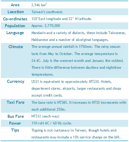
In the 15th Year of the Yongli Era (1661) during the Ming Dynasty, the Wan-Nien County government was located in Singlongjhuang’s Bizihtou. This is now the site of Zuoying Old Town. Areas such as Zuoying, Youchang, Houjin, Cianjhen and Nanzih are all settlements from that period. When the Ching Dynasty took over, these areas were under the administration of Fongshan County. The government remained in the Old Town until 1788, when it was relocated to Fongshan City in Kaohsiung County.

The earliest Han settlers built homesteads in Cihou. The settlements then expanded to areas such as Cianjin, Dagangbu, Wukuaicuo, Lizihnei and Lingyaliao. The fishing and marine trade began near the end of Ching Dynasty in 1862. Shaochuantou and Cihou became large ports for trade. It was then Kaohsiung gradually began growing into a city and its importance to Taiwan began to immerge.

Originally Kaohsiung was simply a large bamboo thicket inhabited by the Makatau tribe. They had named the area “Takou”. During the Japanese Colonial period the Takou Office was located on Cijin Street. The Takou Branch Office of the Tainan Governor was moved to Shaochuantou. In 1920, the Japanese established a Kaohsiung State. The name Kaohsiung comes from the Chinese pronunciation of the Japanese written form of “Takou”. In 1924, the area was renamed Kaohsiung City. This was when Kaohsiung officially became a city. In 1979, it was recognized as Taiwan’s second municipality.


Geography

Kaohsiung is located Taiwan’s Southwestern region and is a long narrow stretch of land. Its total area consists of 2,946 square kilometers. Chianan and Pingtung plains are located on the north and east sides. The Taiwan Straits are located to the west and the Bashi Channel to the south.
Geographically it is in an ideal location. The large harbor makes it an important trade and commerce stop along the Northeast Asia / South Pacific passageway. This has quickly propelled the development of this international city.

Kaohsiung has an international airport with direct flights to a variety of Asian cities. Other international cities can be reached by transferring at C.K.S. International Airport in Taoyuan. There are approximately 50 flights a day between Taipei and Kaohsiung. The flight takes approximately 50 minutes. The Zihciang express train takes 270 minutes and inter-city buses 300 minutes.


The Port

Kaohsiung’s Port is located in the southwest end of the city. It is Taiwan’s largest international port, and the world’s 6th largest container port. The port is quite spacious. There’s also a long sandbank, which makes it a scenic natural harbor. The port’s area is approximately 26.66 km2 and 18 kilometers of navigation channels. The harbor is organized into two parts (1st and 2nd port). The port can process large cargo ships of up to 100,000 tons. The Kaohsiung Port also plays an important role in the tourism industry.

The port pic


Map of Kaohsiung's Eleven Administrative Districts

Map of Kaohsiung's Eleven Administrative Districts

From: http://khh.travel/en/spots/AboutKh.aspx